This article was originally published on AbsoluteHistory
Adventurers have squandered many lives and fortunes tracking down lost civilizations, and despite every fake and failure, the rare successes make all the risks worthwhile. That was certainly the case for these stunning South American ruins. Since their modern rediscovery, thousands of visitors have taken in the stone monoliths and awe-inspiring vistas. But now that the community's macabre origins are becoming impossible to ignore, what does the future hold for this mountaintop oasis?
Andes vista
Every year, thousands of tourists from around the world flock to the Andes Mountains in Peru. They spend days traversing the rugged terrain — not an ideal vacation for most.
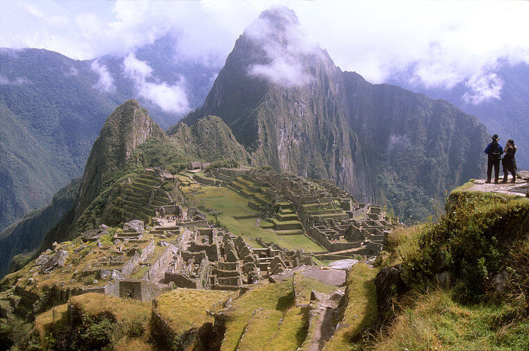
But the trek is all worth it in the end. Atop the mountain range, the travelers reach the iconic skyline of Machu Picchu. This breathtaking settlement may take the cake as the most beautiful sight in the world. Oddly enough, however, history entirely forgot its existence for centuries.
Origins
The famed Inca Empire constructed Machu Picchu in the 15th century. Fifty miles north of their capital city of Cuzco, the site displayed their immense wealth and technology.

The Inca people had no written language, so much of the history and understanding of daily life is based on hypotheses and physical evidence uncovered by archaeologists. Of course, a city as prosperous as Machu Picchu attracted more foes than the Incas could handle—that much we do know.
Pizarro's destruction
Seeking gold and Catholic converts, Spaniard Francisco Pizarro swept through South America in 1532. While the native peoples vastly outnumbered the conquistadors, Pizarro had guns and horses on his side.

The Pizarro and his men ruthlessly sacked Cuzco and executed Emperor Atahualpa. Nearly all of the Inca civilization lay in ruins, and yet the soldiers never got anywhere near Machu Picchu. The city was already abandoned and forgotten.
Tracking down the lost city
In fact, the remote settlement may have remained a mystery forever if not for the efforts of Hiram Bingham III. An esteemed Yale historian, Bingham left the classroom behind to chase down a myth he couldn't get out of his mind.

Maps and records saved from the Incas' destruction indicated a city high up in the mountains. Many claimed the site was lost or fictional, but Bingham trudged through jungle and mountains to find out.
A stunning feat
The explorer shocked the world by reaching Machu Picchu in 1911. While it was clear that no humans had lived there for many generations, the lofty community was in remarkably good shape.

It was nothing short of a marvel. "Machu Picchu" roughly translated to "old mountain," and Bingham saw exactly why. Its former residents carved terraces into the mountainside, where they could farm crops without returning to the valley.
Strange layout
Curiously, the couple hundred buildings in the settlement didn't resemble any other urban layout designed by the Incas. Clear divisions separated groups of stone structures, many of which didn't appear to be residential.

Following Bingham's discovery, Machu Picchu quickly established itself as one of the marvels of the known world. Archaeologists continued to flock there to determine why the Incas built a city in the mountains.
Strange artifacts
One of the bigger surprises was the abundance of sacred artifacts scattered throughout the settlement. Though the number of houses indicated that about 750 people lived there, Machu Picchu had entire sections devoted solely to religion.

More luxurious residences were set aside for Inca nobles, who used them as a retreat, while smaller houses likely served as temporary lodging for pious Incas making a pilgrimage. Historians found many references to a chief deity.
Offerings to Inti
That would be Inti, the Inca god of the sun. The elevation and labyrinthine layout of Machu Picchu reflected his astronomical prominence, though some of Inti's followers paid tribute to him in the most horrific way possible.

Various relics and skeletal remains around the city suggested that residents of Machu Picchu regularly practiced human sacrifice — often with children. Grisly as these killings were, they were only the second darkest mystery buried within the city's walls.
Where did they go?
Of course, the biggest question asked where all the people of Machu Picchu went. Although it was far from a metropolis, 750 people didn't just disappear overnight.

And the city showed no signs of an attack or natural disaster. With those options off the table, many theorize that disease is to blame. European contact with the New World unleashed a legion of diseases. The demise of Machu Picchu likely came from a smallpox outbreak, as the Incas had no resistance or medicine for it.
Dangerous plot
However, the greatest threat to this wonder may just be arriving. Each year, 1.5 million well-intentioned tourists visit Machu Picchu, but their crowded presence tears up the ground and leaves behind litter.

Recognizing the city as a cash cow, the Peruvian government has also considered building an airport right by the secluded site. Machu Picchu's excessive popularity could wipe out the last vestige of Inca life. Some are frantically working to unlock its secrets before it's too late.
Rualdo Menegat
One such specialist is geologist Rualdo Menegat, who has been studying Machu Picchu for years in a bid to unravel the mystery of its construction. At times, he conducted fieldwork at dizzyingly high altitudes, taking measurements from the ancient city itself.

On other occasions, however, he pored over data in a laboratory thousands of miles away from the Andean peaks.
A new perspective
Finally, in 2019, Menegat was ready to reveal the fruits of his labor to his peers. So, at an annual gathering of geologists, he outlined his theories about how Machu Picchu had been built – and why.

And now, these remarkable findings inspire others to look at the Inca Empire in a new light.
Strange techniques
Today, it’s believed that the Incas used a dry-stone technique to build the city’s remarkable stone walls. This means that the rocks were cut and fitted together without utilizing mortar.

But how did these ancient people carry out such a detailed and challenging feat? And why did they choose to do it in such an isolated spot?
Seeking isolation
Well, Menegat – a researcher at Brazil’s Federal University of Rio Grande do Sul – sought to answer those questions. He noted, too, that the Incas appeared to have made a habit of constructing their cities in isolated and inaccessible locations.

And as a geologist, he believed that the reason for this choice may lie somewhere below the ground.
Knowing the land
“It seemed to me that no civilization could be established in the Andes without knowing the rocks and mountains of the region,” Menegat explained to Newsweek in September 2019. “It could not be built on a whim.

It is part of a practice of building settlements in high rocky places. But what guides this practice? What knowledge of the rocks and mountains did builders need to know to succeed in building cities under these conditions?”
Mapping the area
According to Menegat, this area had also not been explored by any previous research, leading him to conduct his own study of the geology surrounding Machu Picchu.

Using a combination of satellite photos and measurements taken at the site, he began to map the tectonic faults that crisscross the region.
Living on fault lines
Long before the Incas and Machu Picchu emerged, though, a tremendous geological upheaval had created the Andes Mountains. Millions of years ago, the two sections of Earth’s crust, the Nazca Plate and the South American Plate, collided.

A high ridge of rock formed as the Nazca Plate was pushed beneath the South American Plate.
Going deep
In an attempt to understand the landscape surrounding Machu Picchu, then, Menegat conducted four separate field trips to the region. When he wasn’t up in the mountains, meanwhile, he pored over data in his university laboratory.

And along with satellite imagery, Menegat used previous geological studies of the area to inform his research.
Checking the work
What’s more, Menegat was impressively thorough with his work. “At each stage of the research, I presented the results to Peruvian researchers from various fields of knowledge – geology, archeology, anthropology, architecture, urbanism, landscape ecology, and epistemology – and regions of Peru, so as to assure me of the correctness of data...

I also evaluate the scope and importance of my findings for Andean culture researchers,” he explained to Newsweek.
An insurance nightmare
Eventually, though, Menegat’s research led him to a singular, startling conclusion. Machu Picchu seemed to have been constructed in a spot that most modern builders would steadfastly avoid: right on top of a series of tectonic faults.

An entire network of cracks in the Earth’s crust seemingly ran beneath the city.
100 mile fissure
And according to Menegat, these faults vary in size. Indeed, while some of these breaks are little more than fissures, others stretch considerable distances beneath the mountains, with one particularly impressive example clocking in at more than 100 miles in length.

A number of the faults also travel from northwest to southeast, while others run from northeast to southwest.
X marks the spot
There’s so much geological activity here that five separate faults converge beneath Machu Picchu – creating an ominous X to mark the spot. And Menegat believes that this is unlikely to be a coincidence.

Instead, he has argued that the tumultuous terrain is integral to the city's structure.
Building on the fault lines
While studying Machu Picchu, Menegat observed that all of its main structures were built in alignment with the faults beneath the city. “The layout clearly reflects the fracture matrix underlying the site,” he explained in a press release from the Geological Society of America.

Shockingly, the mountain stronghold of the Incas is not the only settlement to have been built in such a manner.
Consistent style
Yes, Menegat discovered several additional Inca cities aligned along geological features. The ruins of Ollantaytambo – less than 20 miles from Machu Picchu – are also believed to be located at the intersection of several tectonic faults.

And 50 miles to the east at Pisac, a similar underlying structure can be found.
Old superstition
Menegat even claims that the Inca capital of Cusco was once constructed in alignment with the geological faults beneath the city. But why would these ancient people have chosen to build their settlements in such a way?

Could it be the result of an age-old superstition, or perhaps even a choice with ritualistic connotations?
Using the lines
Well, Menegat believes that Inca culture actually had nothing to do with it. On September 23, 2019, the researcher presented his findings at the annual meeting of the Geological Society of America in Phoenix, Arizona.

And during his talk, the researcher put forward a novel explanation: the Incas actually used the faults to lighten the physical load of building cities.
Perfect materials
Yes, according to Menegat, the Incas specifically sought out areas of geological turmoil as locations for their cities.

Since the stoneworkers who built the famously perfect walls were experts at their craft, the specialist claims, they knew that the fractured rocks found above tectonic faults would provide the ideal building material.
Working with the land
“Where faults intersect, the rocks are even more fractured,” Menegat told Newsweek. “Therefore, they are places that have more loose blocks on the surface, and [these are] also places where [the rocks] can be easily removed to build terraces and buildings.”

However, that wasn’t the only advantage of constructing cities on these sites.
Naturally geometric
Menegat has gone on to explain that the fractured rock was also naturally set into geometric shapes such as hexagons and triangles – meaning the materials should have slotted together more smoothly.

And if the pieces of stone were not the correct shape, then their fragile nature would have made it easier to cut them down.
Easy to carve
“The intense fracturing there predisposed the rocks to break along these same planes of weakness, which greatly reduced the energy needed to carve them,” Menegat explained in the press release.

In fact, in the geologist’s opinion, the construction of Machu Picchu would have been “impossible” without these conditions.
Sophisticated water system
However, Machu Picchu’s position on top of several tectonic faults didn’t just make the workload more manageable.

According to Menegat, this specific geology also funneled melted ice and precipitation toward the city, providing a ready source of clean water to the community despite the inaccessible mountain location.
Making the inhospitable hospitable
“The Andean world is inhospitable,” Menegat told Newsweek. “Here, human life is possible only in a few places where water drips through fractures.

The Incas knew to follow this criterion, which allowed them to establish networks of settlements in this kind of oasis of habitability provided by the faults and fractures.”
Supporting 10 million
Owing to the water from the mountains, the Incas didn’t need to build in the low valleys, thus reducing the risk of danger from rockfall and flooding.

These unlikely but surprisingly sustainable cities were so successful that, in total, they were able to support a population of some ten million people.
Natural drainage
But Menegat believes the fractured rock beneath Machu Picchu had another purpose. While heavy rain was sometimes a problem even this high up in the Andes, the region's geology could have provided natural drainage and helped protect the site from flooding.

This feature may have prevented the city from falling further into ruin after it was abandoned.
Genius subsurface
“About two-thirds of the effort to build the sanctuary involved constructing subsurface drainage,” Menegat explained in the press release. “The pre-existing fractures aided this process and help account for its remarkable preservation.

Machu Picchu clearly shows us that the Inca civilization was an empire of fractured rocks.”
Quijlo
Fascinatingly, Menegat also revealed that the Incas had their own way of describing the tectonic activity on which their cities were built. “There is a Quechua word for large fractures,” he told Newsweek.

“As the great Peruvian writer José Maria Arguedas said, the Incas called the fractures that crossed the mountains ‘quijlo.’ Geologists call them faults.”
Reading the rocks
But does this mean that the people who built Machu Picchu had an incredibly advanced comprehension of geology for the time? While they may not have known the cause of tectonic faults, Menegat believes they could spot them.

“The Incas knew how to recognize intensely fractured zones and knew that they extended over long stretches,” he continued.
Lasting architecture
Amazingly, then, the Incas’ knowledge of faults enabled them to build structures that were to last for more than 550 years. But just as researchers such as Menegat are beginning to understand the secrets of Machu Picchu, the ruins are more at risk than ever.

If plans to construct an airport just a few miles away are carried out, the hub will bring dangerous numbers of visitors to the already crowded site. And although archaeologists are petitioning against the development, the future of the ancient city continues to hang in the balance – for now.
Looking to their neighbors
Menegat and fellow researchers often take clues from neighboring communities that existed simultaneously. We now know several lost civilizations were deep in South America, within the Amazon rainforest.

European explorers and neighboring communities noted the careful construction of settlements. However, even the closest neighbors wouldn't understand the villages' brilliant designs without 21st-century technology.
History now
Close to the Brazilian section of the Amazon, settlements of ancient indigenous tribes have become lost in the changing landscape. However, a recent study showed how modern technology has been used to uncover what the human eye can't see.

An archaeological team, confident that they could find what so many others had missed, took to the skies over the rainforest with LIDAR. Short for "Light Detection and Ranging," the equipment had lasers that scanned the land. Nothing of the kind had been attempted before.
Looking back
Could LIDAR pick up on traces of extinct communities in the Amazon? Much of what occurred on the land before colonization took over has been unknown.

Historians agreed on a few common facts from the pieces of history that survived, but much of those previous civilizations have been destroyed. So much more information was needed.
Deadly missionary
Friar Gaspar de Carvajal, a Dominican missionary, chronicled what he found upon exploring the New World. He wrote about a developed network of roads he had seen.

More recently, his writings have been deemed reliable, primarily based on some of his claims. Though dedicated to locating and converting indigenous tribes, Carvajal nearly brought about their extinction. He didn't realize it, but Carvajal transported diseases from the Old World that the tribes had never dealt with before, killing many. Still, he wasn't the last outsider to visit.
Another expedition
By the 1700s, another explorer made his own declaration of what he found within the Amazonian land. Colonel Antonio Pires de Campos stated he witnessed large populations within the area.

Of course, other outsiders who'd traveled through had no such experience.
Going forward
During the years between then and now, historians couldn't find any evidence of this hidden jungle civilization. Try as they might, the rainforest was too dense to survey.

With no tangible proof other than the explorers' writings, many experts thought little of these theories.
21st century success
Enter LIDAR. The laser technology became a game-changer in overturning assumptions and seeing the unseen.

When its pulsed lasers are aimed at a targeted area, they return to a sensor. In doing so, they bring back accurate measurements of the land and a 3D map.
Better opportunities
Not only has the method become a reliable one, but a safer one. Experts don't have to navigate the tough terrain of overgrowth and wild animals.

More importantly, the destruction and disturbance of the land is no longer needed to read into its past.
Past reveals
The resulting LIDAR images revealed that Carvajal and Pires de Campos had not lied about their findings. Nor had they embellished what they had seen.

The two had been correct all along! There was definitive proof of these Amazonian settlements, and their layout was astounding.
Maps of truth
A total of 35 villages had been scanned. They date back between the 14th century and the 18th century.

While the range was broad, it was the settlements' design that truly was awe-inspiring. These were far more advanced than groupings of huts in the rainforest.
Network cluster
"Mound" villages, shaped like circles and rectangles, were discovered about 3 miles apart. As their names suggested, the villages took the form of pilings surrounding a central plaza.

They formed some interesting patterns, too. Among the roads that crossed through the villages were two primary routes. They stretched out, both 20 feet wide and formed into high banks. It was these larger roads that reached other settlements.
Cosmic connection
In each and every area pictured, the intricate network of roads sprouted out like a clock hand. Or maybe they were something else altogether?

The archaeological team published their findings in Journal of Computer Applications in Archaeology. The team stated that the roads in the images were “like the rays of the sun, which gives them the common name of ‘Sóis,’ the Portuguese word for ‘suns.'” In fact, all of the structures seemed to mirror some celestial body.
Solar power
Could the old Amazonian tribes have looked far up to the skies for inspiration on their settlements? It's simply a theory currently, but one that holds up well due to the layout.

These peoples could have designed their homes to resemble the constellations due to their way of life.
Ancient powers
The maps revealed a history of Amazonian tribes with a strong soil-engineering culture. What is most essential for crops to thrive?

The power of the sun that looms overhead. It was — literally and figuratively — the center of their world. Many civilizations throughout South America had a special devotion to the sun and the cosmos.
Sky worship
Over along the western edge of South America, the Incan empire worshipped the sun as a deity. The sun was necessary for the warmth and life that it provided.

When a total solar eclipse plunged the world into darkness, the Incas performed rituals of fasting and sacrifices to better please their deity and return the sun to them.
Modern mysteries
With the LIDAR equipment at their ready, it's very possible the archaeologists' theory will become fact and uncover further settlements of the past.

These constellation-based Amazonian villages could unlock secrets for former civilizations throughout Mesoamerica and even further aid in Menegat's research of the Inca.